 NERC Data Catalogue Service
Sedimentary geology
Type of resources
Topics
Keywords
Contact for the resource
Provided by
Years
Formats
Representation types
Update frequencies
Scale
-
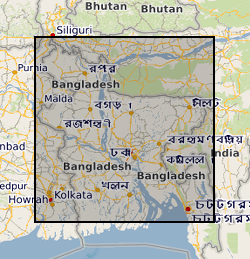
This dataset contains data from a river multibeam and seismic survey which took place in 2013 and 2014 at scour sites within the Brahmaputra river basin in Bangladesh. The survey was carried out as part of a joint project between the Universities of Birmingham, Southampton and Exeter. "The sedimentology of fluvial megascours" was a scientific research project funded by NERC. The purpose was to collect the data necessary to validate the first generic numerical model of scour zone stratigraphy that will be widely applicable to a broad range of large rivers. River bed bathymetry data were collected using a multibeam echosounder. Sub bottom seismic profiling data were collected using a surface tow boomer and chirp system. Technical details of the survey are contained in the cruise report of the survey which comprises part of the metadata. Some of the data has been accepted for a publication in the journal 'Sedimentology' which will be published in 2018 with the title 'The Sedimentology of channel confluences'.
-

This dataset contains numerical model output of a morphodynamic and sedimentological simulation of a large river confluence based loosely on the Jamuna-Ganges junction in Bangladesh. The work was carried out as part of a joint project between the Universities of Birmingham, Southampton and Exeter. "The sedimentology of fluvial megascours" was a scientific research project funded by NERC. One aspect of the project was to undertake numerical simulations (the data described here) with which to compare with river bed bathymetry data (collected using a multibeam echosounder) and sub bottom seismic profiling data (collected using a surface tow boomer and chirp system). The data has been accepted for a publication in the journal 'Sedimentology' which will be published in 2018 with the title 'The Sedimentology of channel confluences'.
-
A series of technical palaeontological and biostratigraphical reports produced in the London, Leeds, Edinburgh and Keyworth offices of BGS between 1953 and March 2000. The reports provide information on fossils collected during Geological Survey mapping or supplied by clients. Fossils are collected in order to date (relative age) the rocks in which they occur and/or to provide evidence for the conditions of deposition, so the information contained in each report usually includes determinations of the fossils present in a collection and an interpretation of their stratigraphical and/or their palaeoenvironmental/palaeogeographical significance.Individual reports vary enormously in scope, depending on the reasons for the investigation. Some reports may be site specific, documenting the fossil fauna/flora from a particular locality or borehole, whereas others may deal with material from a number of localities on a 1:10 000, 1:25 000 or 1:50 000 sheet, or from several boreholes. Other reports may be in the form of reviews. Geographical coverage is wide, covering the UK and Northern Ireland onshore, UK offshore and overseas localities.All reports are held as hardcopy only. Each report bears a unique identifying number in the form SS/YY/NN, where 'SS' identifies the series, 'YY' identifies the year in which it was written and 'NN' is a serial number. Reports were numbered sequentially, regardless of whether they dealt with material from the UK and Northern Ireland onshore, UK offshore, or overseas, and a sequential set is held by BGS. Reports are also filed by 1:50 000 sheet, (UK onshore), offshore quadrant and foreign country, as appropriate.
-

The data set consists of rock samples collected from Burnmouth, a core drilled at Norham, from Crumble Edge, Willie's Hole and Nova Scotia from 2012-2016; milled material is included. There is an Excel spreadsheet of sample numbers with location, sample height on log, lithology and fossil content. Scans of field logs from Burnmouth, Crumble Edge, Edington Mill, Pease Bay (UK) and locations in Nova Scotia, and overview drawn-up logs from Burnmouth, Norham, Crumble Edge and Willie's Hole are included. Scans of thin section scans are also included. There is a spreadsheet containing geochemistry data - sample numbers with lithology and %C, %S, d13C. These data were used to interpret the environment in which early tetrapods have been found in the early Carboniferous. Publications include: Bennett et al., 2016 (doi: 10.1111/sed.12280); Bennett et al., 2017 (http://dx.doi.org/10.1016/j.palaeo.2016.12.018 0031-0182); Clack et al., 2016, (DOI: 10.1038/s41559-016-0002); Kearsey et al., 2016 (http://dx.doi.org/10.1016/j.palaeo.2016.05.033) ; Clack et al., 2018, (doi:10.1017/S1755691018000087); Millward et al., 2018 (doi: 10.1111/sed.12465); Ross et al., 2018 (https://doi.org/10.1017/S1755691018000142)
-
The data set consists of rock samples collected from Coquetdale, Coldstream and Whitrope Burn from 2013-2014; milled material is included. There is an Excel spreadsheet of sample numbers with location, sample height on log, d13C data and %C. There are scans of field logs from Coquetdale, Coldstream and Whitrope Burn, and Illustrator drawn logs from Coldstream which include samples collected at a later date. Scans of thin sections are also included. (thin sections to be kept at Leicester for the time being – still being worked on for papers.) Each locality folder has an Excel spreadsheet detailing samples, sample height, %C and bulk and specific d13C values. These data were used to interpret the environment in which early tetrapods have been found in the early Carboniferous. These data supported the MPhil thesis 'In an alternating marine and non-marine depositional setting, where and how are early Carboniferous tetrapods preserved?' by Sherwin, 2018, and one publication including data from Whitrope Burn - Richards et al., 2018, (https://doi.org/10.1017/S1755691018000166).
-
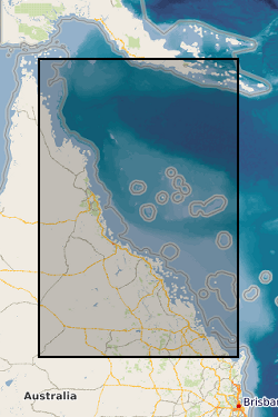
Four datasets for NERC grant NE/J023329/1, Paluma Shoals reef complex, Halifax Bay, central Great Barrier Reef, Australia. DATASET 1: Single Beam acoustic survey data. This dataset comprises the single beam acoustic data that was collected from transects across the Paluma Shoals reef complex, Halifax Bay, central Great Barrier Reef, Australia. The dataset comprises of depth measurements (m) and the latitudinal and longitudinal coordinates of 58,255 point samples across the study area. The dataset was used to construct Figure 1C in Morgan, K. M., Perry, C. T., Smithers, S. G., Johnson, J. A., & Daniell, J. J. (2016). Evidence of extensive reef development and high coral cover in nearshore environments: implications for understanding coral adaptation in turbid settings. Scientific Reports, 6. DATASET 2: Paluma Shoals core data (sedimentology and palaeoecology This dataset includes all collected sedimentary and coral palaeoecological data collected from cores from across the Paluma Shoals Reef Complex, Halifax Bay, central Great Barrier Reef, Australia. This includes 1) a list of the cores recovered, their geographic location and their depths; 2) data on the mud and carbonate content of the sediment matrix from each core; 3) grainsize data from each core; 4) data from thin section analysis from each delineated facies in cores; and 5) downcore data on coral constituent abundance. DATASET 3: Core radiocarbon dates This dataset comprises the radiocarbon dates obtained from coral samples from cores collected across the Paluma Shoals Reef Complex, Halifax Bay, central Great Barrier Reef, Australia. Dates are from the NERC Radiocarbon dating lab (SUERC) in East Kilbride. DATASET 4: Benthic video imagery This dataset comprises screen grab images collected along towed transects across the Paluma Shoals reef complex, Halifax Bay, central Great Barrier Reef, Australia. Each image has the relevant lat, long coordinates printed on the top right hand corner. The sites names (folders) relate to the sites described in the following paper: Morgan KM, Perry CT, Smithers SG, Daniell JJ and Johnson JA (2016) Extensive reef development within the “mesophotic” nearshore Great Barrier Reef: Evidence for intra-regional variations in coral resilience. Scientific Reports 6:29616. DOI: 10.1038/srep29616
-

This dataset contains the collated wireline logs, stratigraphy and core analysis of the three boreholes drill as part of the publicly funded Rapid Global Geological Events Project (RGGE) which ran between 1995-1998. The aim of the RGGE project was to identify the effects of climatic changes on modern sediments. The project focused on the Kimmeridge Clay due to its unbroken sequence of fossiliferous marine mudstones. These mudstones have compositional variations in organic content, minerology, fauna and clay content which reflect changes in both the climate and sea level. Over the course of the project the entire sequence of the Kimmeridge Clay was cored across three boreholes, two at Swanworth Quarry and one at Metherhills.
-
This is a geochemical dataset accompanying Emmings, J., Poulton, S., Vane, C., Davies, S., Jenkin, G., Stephenson, M., Leng, M., Lamb, A., Moss-Hayes, V. A Mississippian Black Shale Record of Redox Oscillation. Palaeogeography, Palaeoclimatology, Palaeoecology [submitted July 2019]. This dataset includes RockEval pyrolysis, major and trace element (XRF), Fe speciation, C, N and S isotopes and S species analyses through the Upper Bowland Shale in the Craven Basin (Lancashire, UK). This research was conducted by Joe Emmings, PhD researcher at the University of Leicester and British Geological Survey (BGS) between 2014-2018, and as a post-doctoral research associate (PDRA) at the British Geological Survey (2018-2021). The PhD research was funded by the Natural Environment Research Council (NERC), as part of the Central England Training Alliance (CENTA) [grant no. NE/L002493/1] and received CASE funding from the BGS. PDRA research was funded by the British Geological Survey. Reproduction or manipulation of these data in future analyses should cite one or more of the following related publications (as necessary): Emmings, J., 2018. Controls on UK Lower Namurian Shale Gas Prospectivity: Understanding the Spatial and Temporal Distribution of Organic Matter in Siliciclastic Mudstones. PhD Thesis, University of Leicester. Emmings J. et al. 2017. Stream and slope weathering effects on organic-rich mudstone geochemistry and implications for hydrocarbon source rock assessment: a Bowland Shale case study. Chemical Geology. 471. 74-91. Emmings, J. et al., 2019a. From Marine Bands to Hybrid Flows: Sedimentology of a Mississippian Black Shale. Sedimentology, [Accepted ms.]. Emmings, J.F. et al., 2019b. Controls on amorphous organic matter type and sulphurization in a Mississippian black shale. Review of Palaeobotany and Palynology, 268: 1-18. Emmings, J.F. et al. A Mississippian black shale record of redox oscillation. Palaeogeography, Palaeoclimatology, Palaeoecology [submitted July 2019] Co-workers: Sarah Davies (University of Leicester) - Primary PhD supervisor, sedimentology Chris Vane (BGS) - PhD supervisor, RockEval pyrolysis Mel Leng (BGS & University of Nottingham) - PhD supervisor, C & S isotopes Mike Stephenson (BGS) - PhD supervisor Simon Poulton (University of Leeds) - Fe speciation Gawen Jenkin (University of Leicester) - PhD supervisor Vicky Moss-Hayes (BGS) - RockEval pyrolysis Angela Lamb (BGS) - S isotopes